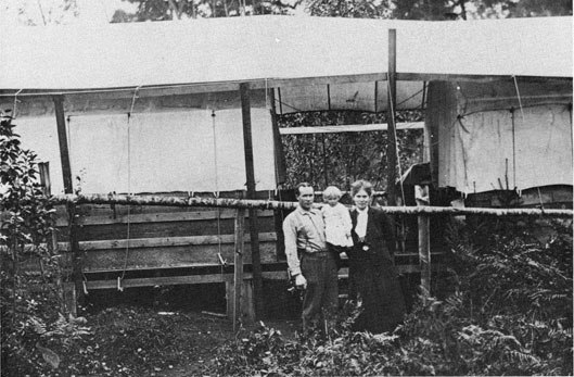
Henry and Clara Husby, shown here circa 1910 with daughter Helen, made do with this tent
house until their permanent-structure home could be completed Henry was the town's first storekeeper. (photo courtesy of
Henry Husby)
It was a most desirable location, that peninsula of virgin land. With a border of clear waters
free of the rough currents that rocked nearby Puget Sound, it was irresistible to the early
pioneers, and later to the U.S. Navy in search of its ideal torpedo test range.
For the pioneers, who painstakingly cleared and cultivated the peninsula by hand, it was a haven
for fishing, farming, and ranching.
The first known homesteader in the area was Olaf Stub, who came with his son Henry in 1880.
Francis Oscar (F.O.) Ekstedt and his wife Hannah soon followed in 1883 and settled in what is
now South Keyport. The area proved popular and attracted still more homesteaders who settled
in as the 19th century wound its way to a close.
By 1900 enough homesteads had risen from the forest to warrant a name for the fledgling town.
Peter Hagen and brothers Oscar and H.E. Kuppler took the lead. Studying a map of the United
States, they found -and decided on-the name Keyport. A perfect choice, Peter argued, since the
townsite was really the key to Dogfish Bay (later renamed Liberty Bay) off Poulsbo.
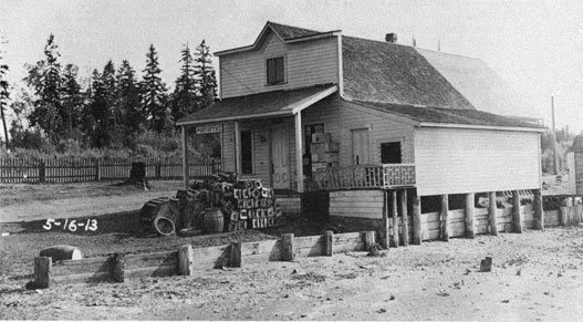
The Keyport general store was built in 1903 and run by a young man named Henry Husby who
later married Clara, daughter of pioneer F.O. Ekstedt. The store
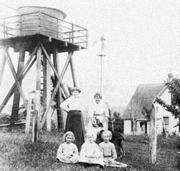
The Hagen farm was equipped with a water tower and windmill to provide "modern" running
water in the home. Standing is Gunda Hagen, left, with an unknown visitor and dog. Showing
their Scandinavian descent are children Esther Norum, Viola Hagen, and Hanna Norum. (photo
courtesy of Alice Norum Peterson)
5
Andrew Hanson built Keyport's first General Store and Post Office and leased the building out to
storekeeper, Henry Husby. The store, perched on the edge of the beach, was next to the
community dock at the end of the peninsula. The building was moved in 1914 to the newly
developed town of Keyport at the edge of the torpedo station, and it remains there today as the
Keyport Mercantile. (photo courtesy of Alice Norum Peterson)
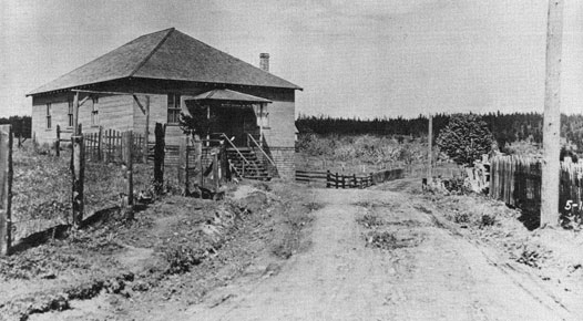
Residents on the peninsula looked forward to Saturday night socials at the Grange Hall. "This was
a way to eat out as there were no restaurants," said Esther Norum Sommerseth, who was a child
at the time. Musicians entertained, a clergyman delivered a sermon, and neighbors got caught up
on each others' comings and goings. Socials were often held to raise funds for needy people. This
building was later used as a barracks for Station sailors for nearly 25 years.
6
was located on the tip of the peninsula and had a dock for all residents to use.
The first county road between Keyport and Brownsville was opened that year, creating a much
needed link.
The Keyport area continued attracting homesteaders throughout the early part of the century.
Five of those families had, unfortunately for them, chosen to live on the peninsula which
eventually became the torpedo station: Hagen, Husby, Norum, Petterson, and Thompson.
In 1914, when they were required to leave, the families, all of whom expected to spend a
lifetime as neighbors on their quiet peninsula,went their own ways.
When Peter Hagen and the Kuppler brothers named the town, they posted a sign declaring it
"Keyport." There was some opposition to the new name, however, and an unknown critic pulled
down the sign. Peter reposted it, but before he knew it, it was down again. The sign went up and
down, over and over, until the critic gave in and the name "Keyport" prevailed.
The Albion and Dingo rest quietly with another boat for the winter in the sheltered waters
between Virginia Point and Cove Point. These two fishing boats were owned by Carl "Pete"
Peterson and W. Carlson, neighbors on Cove Point, or Crowder Point, as it was known in
Keyport for years. The building was used for storing nets.
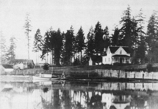
The home of Alfred Petterson sits quietly on the shores of the South Lagoon. This home was
salvaged by the Navy and was used for many years as Quarters B. (photo courtesy of Ruth Reese)
7
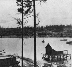
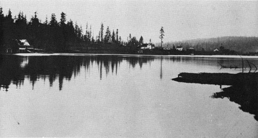
The peninsula had two lagoons. The North Lagoon, shown near the store and dock provided a
small safe harbor for fishing boats and a swimming hole for the children. Much of the lagoon has
been filled-in today, but its sandbar still exists and can be seen at low tide near the
Station's Mk
48 Torpedo Shop, Building # 514.
The South Lagoon was much larger than the North Lagoon and it, too, was reduced greatly in size
some years later to increase the land-area of the torpedo station.
8
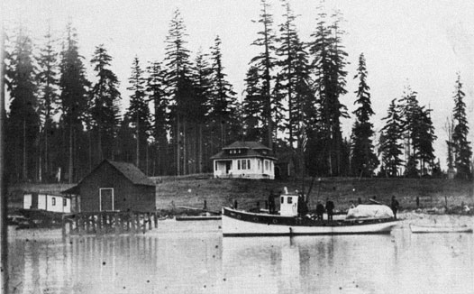
Early residents earned their livings by farming, ranching, and especially fishing. If a man
didn't
have a fishing boat, he strove to get one, as fishing was one of the most reliable sources of
income. This photo was taken just off the area outside of what was to become the Pacific Coast
Torpedo Station. (photo courtesy of Alice Norum Peterson)
The Husby's moved the store, building and all, just outside Navy land to an area newly developed
into lots and streets by A. B. Moe. The Pettersons settled in town as well, while the Hagens and
Norums barged their belongings across Liberty Bay to Lemolo. The Thompsons left the area
altogether and settled in Seattle.
Legend has it that Dogfish Bay was so named because its waters were so thick with dogfish that
the pioneers could literally rake them onto shore.
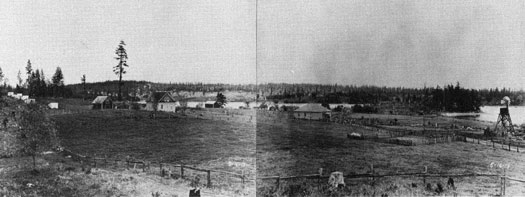
There were few horses available to the Keyport Peninsula pioneers. Most of the clearing and
planting was done by hand. This photo, taken in 1913, shows the lay of the land and existing
structures, looking northeast. From left, the Norum home, Hagen home, grange hall general
store (in distance), and Thompson home. (photo courtesy of Alice Norum Peterson)
9
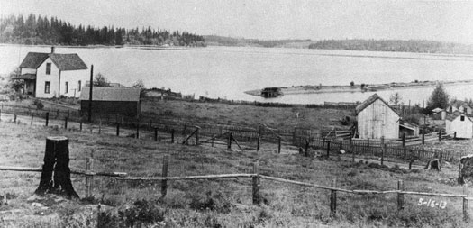
Paul Thompson owned this farm at the mouth of the South Lagoon. This house became Quarters C
when the Navy purchased the land.
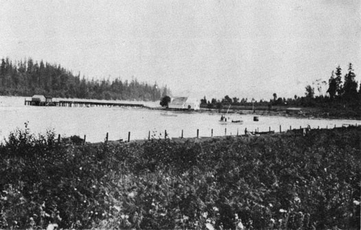
The earliest steamers had no docks for dropping off supplies and visitors. The sound of three
whistles set the
rowboats in motion as residents hurried out to their floats to see what the ship had left for
them.
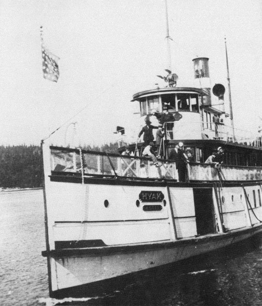
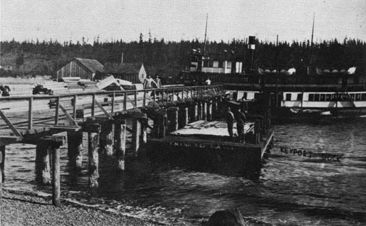
The steamer Hyak makes one of its twice-daily stops at the Keyport dock
10
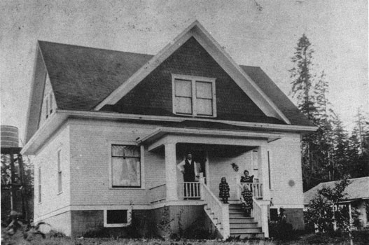
"As a first move toward the permanent improvement of the new torpedo station at Keyport,"
began an article in the October 28, 1914 edition of the Bremerton News, "the navy department
has ordered Commander H.N. Jenson to take command and it is understood that one of the cottages
now being overhauled will be for his occupancy." The 'cottage,' above, was given up by the
Anton Norum family, shown on the porch. The Norums moved to a cabin in Lemolo causing the
children to lament that, although 'camping out' was fun, they missed their big house with its
two indoor bathrooms that Commander Jenson was enjoying. (photo courtesy of Hannah Norum Langer)
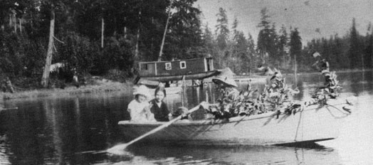
Keyport residents enjoy a row boat ride on the South Lagoon. (photo courtesy of Ron Hoff)